One of the most mysterious concepts in ancient geography and cartography are the Rhipaean Mountains that had for centuries been the object of mythological, cosmological, geographic, cartographic, and poetic discourses. Having originated as a designation of the northern (in relation to Greece) Thracian mountains, where king Boreas dwelt, the name in the course of time became attached to the mountains located allegedly in the extreme north of the oecumene. Many ancient geographers and cartographers tried to identify the legendary Rhipaean Mountains with the real mountain ranges in Northern Eurasia from the Pyrenees through the Alps, the Carpathians, the Caucasus, the Ural, the Altai to the Tien Shan.
The Riphaean mountains in the ancient geography
In this part, we would like to consider briefly the main features of this mythopoetic and geographical concept in the antiquity.
Already the ancient Ionian scientists located these mythical (or semi-mythical) Rhipaean (in the Latin orthography often Riphaean) Mountains (you can see different variants of the name: Ῥιπαί, Ρίπαια ὄρη, Ῥιπαῖα ὄρη, Ripaei/Riphaei montes, Riphei, Ripheus, Rifei, Rifrei, Riffei), in the north, most often the north-north-east of Europe (see for example the reconstruction of world map of Hekataios in the end of the 6^th^ c. BC in ill. 1).
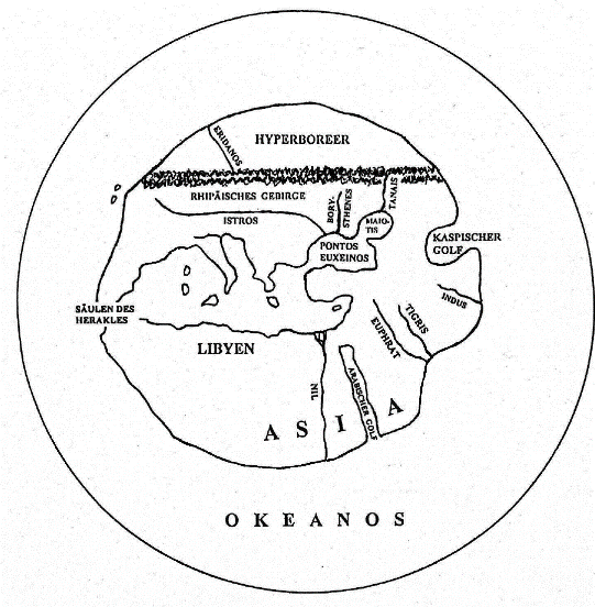
Ill. 1. The reconstruction of the world map of Hecataeus from Miletus (after Geus 2001: 85)
For the first time the Rhipaean name, without indicating their localization, we find in the poem of Alkman in the second half of the 7th century BC in the form of 'Ripas' (F 90 Page: Ῥίπας ὄρος).
Where were situated the northern mountains in Europe, from the point of view of the archaic Greeks? Our analysis of the geographical and cosmological representations of the Homeric Greeks leads to the conclusion1, that Europe in this world picture was limited by Greece itself, washed from the east, south and west by sea (ill. 2). The North remained terra incognita; really it was the Balkan Peninsula.
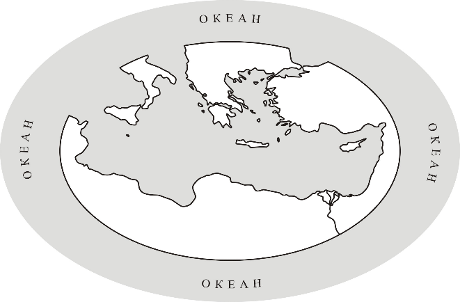
Ill. 2. World picture of Homeric Greeks
In this archaic world picture, the northern horizon of the Greeks was closed by mountainous regions – Pieria, Macedonia, Paeonia and Thrace. So, known then Europe ended in the north in a certain large mountain range. When the periphery of the oecumene was being gradually better acquainted, these mountains were moved to the north of Europe and began to stretch from the Alps to the Urals, preserving their neighborhood with the northern ocean2.
In close connection with the Rhipaean Mountains, from which the northern wind Boreas is blowing, there is a blissful people of Hyperboreans living in the narrow strip of land between Rhipaeans and the Northern Ocean in a mild climate and revering Apollo3. As an example of the combination of these two names, we will quote the words of the Hellenistic poet Callimachus, who in his work "Reasons" speaks of "the sons of the Hyperboreans who accompany the gifts from the Rhipaean mount" to Greece (Delos)4. The very name of the Hyperboreans could be transfered to Rhipaean Mountains, which were sometimes called the Hyperborean mountains5. The ambigous localization of the Hyperboreans supported in antiquity the idea of streching Rhipaeans in Northern Europe and Asia from the Alps to the Tien Shan and even China6. In one of the first mentions of the Hyperboreans they and therefore the Rhipaean Mountains were located in the North-Eastern Europe in connection with the very concrete peoples. This is how, for example, the Greek author Damastes (a contemporary of Herodotus) describes their location: “The Issedones live above (ἄνω) the Scythians, higher (ἀνωτέρω) – Arimaspians, above (ἄνω) them - Rhipaean Mountains, from which Boreas blows and where snow never melts; above them Hyperboreans dwell til the other sea (ὑπὲρ δὲ τὰ ὄρη ταῦτα Ὑπερβορέους καθήκειν εἰς τὴν ἑτέραν θάλασσαν».
It should be noted that in the Roman geographical tradition the Rhipaean Mountains take their place steadily in the extreme north-east of Europe. Valerius Probus in the commentary to Vergils Georgica III, 382, obviously arguing with supporters of the Alpine localization of Rhipaeans, notes that “some people took the Rhipaean mountains for the Alps. But the Riphean mountains proper are in Scythia.” The “Scythian” tradition was reproduced by Mela, Pliny, Solin, Julius Honorius, Paulus Orosius, other Latin authors and in this form was inhereted in the Middle Ages.
In ancient geography, the idea, that all the rivers of oecumene have their origin in the mountains, was widely spread. The rivers, flowing from the Northern Europe, had to originate in the Rhipaean mountains. Perhaps for the first time this idea was perfectly expressed in the middle oh the 1^st^ c. AD by the first Roman composer of geographic work, Pomponius Mela: according to him the Riphaean mountain rises behind the Arempheans, beyond this mountain is the Northern Ocean (I, 117); Riphaean mountain stretches through the north of Eastern Europe (II, 1); they are inhabited by Hyperboreans (III, 36); river Tanais (modern Don) originates from the Riphaean mountain (I, 115). The connection of the Don-Tanais with the Riphaean mountains very soon became as strong as the connection of Riphaeans with the Hyperboreans.
As for the mapping of Rhipaeans in the ancient cartography, it should be noted that very few artifacts have been preserved from antiquity – practically two or three maps, and only on the map of Ptolemy the Rhipaeans are called by this name.7. In the 3^rd^ book (III, 5, 15) Ptolemy mentions several mountains in Eastern Europe (so called European Sarmatia), and among them the Rhipaeans: "Sarmatia is crossed also by other mountains [except Sarmatian ones], between which are called:
Peuce mount 51° - 51°
Amadoka mount 59° - 51°
Bodinon mount 58° - 55°
Alaunon mount 62°30' - 55°
Carpathes mount, as it is said 46° - 48°30'
Venedian mountains 47° 30' - 55°
Riphaean mountains, the middle of which is 63° - 57° 30'.”
On the reconstruction of the map (ill. 3) we see, that Ptolemy has placed the Rhipaean mountains in the northeast corner of European Sarmatia on his map. The origins of Tanais on the map of Ptolemy are not related to the Rhipaeans, although they are near the mountains, somewhat north of them. Such localization breakes drastically with traditional concepts.
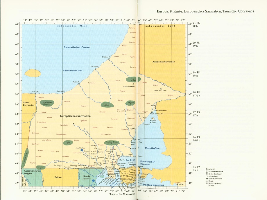
Ill. 3. Map of European Sarmatia after Ptolemy
So, the mythical Rhipaean mountains found their place on the purely "scientific" map of Ptolemy, although their existence was already doubted by Herodotus, Eratosthenes, Apollodorus and Strabo. This shows only one thing – the deep penetration into the mind of the ancient man of the idea, that certain Rhipaean mountains existed somewhere in the north of Eastern Europe.
The Hyperboreans of Ptolemy were separated from the Riphaeans and turned into almost an epithet: in the north of Asiatic Sarmatia, Ptolemy places the Hyperborean mountains (V, 9, 13: Ὑπερβόρεια ὄρη), the river Ra (Volga) flows down from them and about it Ptolemy told: “Hyperborean Sarmatians live in the areas adjacent to the unknown land” (V, 9, 16) (see ill. 4).
So, Ptolemy has depicted both mountains – Riphaean (in Europe), and Hyperborean (in Asia). If we consider that Ptolemy's Asiatic Sarmatia is a part of modern Eastern Europe from the Don to the Urals, then both these mountains are still in Eastern Europe.
The famous ancient map, where we can probably see the Riphaean Mountains, is the so called Tabula Peutingeriana, the Latin map from the first centuries AD8. The river Tanais (Don) takes its origin in some mountains without name (ill. 5). We can suppouse, that these mountains are the Riphaeans, because the whole ancient geography insisted, that Tanais originates just from Riphaeans.
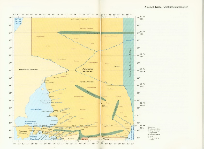
Ill. 4. Map of Asiatic Sarmatia after Ptolemy
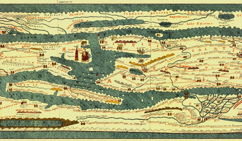
Ill. 5. Tabula Peutingeriana (above to the left are mountains, possibly Riphaean)
These theories were inherited by the Christian cosmological tradition. We mean the concepts of Cosmas Indikopleustes (6th c.) in the east and the Anonymous from Ravenna (6^th^-7^th^ cc.) in the west of medieval Europe. Cosmas wrote only about the elevation of the earth's surface (τὸ ὕψος τῆς γῆς) to the north and west of the oecumene, behind which the sun hides in the night9. The manuscripts of his “Christian topography” contained the image of the mountain in the north of Europe, behind which the sun sets (ill. 6)10.
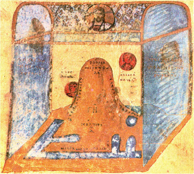
Ill. 6. Illustration from a manuscript of «Christiam topographia” of Cosmas Indikopleustes
So famous Christian cosmographers, denying the sphericity of the Earth and the sky, the existence of Antipodes and other “achievements” of ancient science, retained the notion of the existence of the Riphaean mountains in the north of the flat Earth.
The Riphaean Mountains on the medieval maps
Throughout the Middle Ages and in the following epoch until the 16^th^ century and even further the existence somewhere in the North-East Europe or North Asia of the Riphaean mountains was not particularly questionable. Many medieval maps11 as we will see contain indication of the Riphaean mountains12. Moreover, these mountains were present even on very schematic maps with a small number of geographical objects, which indicates their importance in the minds of medieval cartographers (ill. 7).
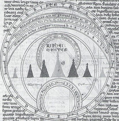
Ill. 7. Climate mappa mundi, Baltimore, Walters Art Museum (end of 12th c.)
The Riphaean mountains were constantly depicted as one of the most ext-reme (or the most extreme) points of the oecumene in the north. On medieval maps, Tanais-Don almost always originates in the Riphaean Mountains (ill. 8). In most cases this mountain range is located directly in the North. Paulus Orosius wrote in 6th c.: “Europe begins, as I have said, under the northern zone from the Tanais River, where the Riphaean Mountains, standing back from the Sarmatian Ocean, pour forth the Tanais flood which passing by the altars and boundaries of Alexander the Great swells located in the territories of the Rhobasci Paludes Maeotidae, immense overflow of which goes widely into the Euxine Sea near the city of Theodosia” (I.2.4)13. And in another place about Europe: “It begins from the Riphaean Mountains, the river Tanais and the Maeotidae Paludes that are to the east...” (I.2.52)14.
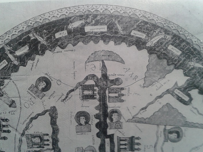
Ill. 8. Fragment of the mappa mundi from the manuscript of In Apocalipsin by Beatus de Liebana (1086 or 1124)
According to Isidore of Seville: “The Riphaean Mountains are at the top of Germany (in capite Germaniae), they were called like that because of perpetual wind blowing; indeed ῥιφὴ and ὁρμή is inrush in Greek, from ῥίπτειν – to throw” (XIV, 8, 8)15. However, on some maps this mountain range appears with a little deviation to the East, in the Asian part of the world16, or to the West, in the European one17 (ill. 9). On the maps with climate zones the Riphaean mountains was almost always located in the northern inhabitable zone or close to the border between habitable and inhabitable ones18. John of Holywood (in Latin Johannes de Sacrobosco) told about the climate Dyaripheos that goes through the Riphaean Mountains19.
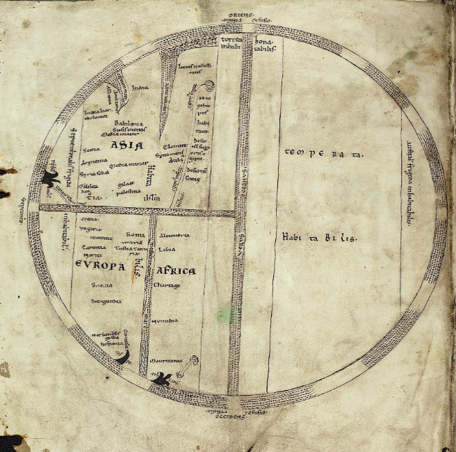
Ill. 9. Heidelberg map from manuscript of Etymologiae by Isidore of Seville, 13th c.
On the classical medieval maps the northern territories were reduced that is especially seen on the detailed ones, in particular of the Ebstorf-Hereford type. That's why the mountains often appear close to the Black Sea. It seems logical because there was little information about the North from traditional renowned sources from which the authors derived the data for their maps. Moreover, the northern parts of the world were populated by wild tribes and monsters in medieval perception. The exception was made in the case of the blessed people of the Hyperboreans who lived outside the area of Boreas blowing, that froze other nations, according to the ancient myth. One can see even the Hyperborean mountains on some of the maps (ill. 10).
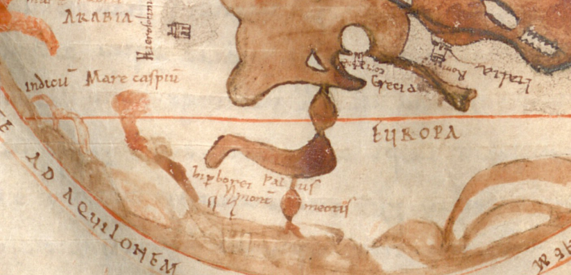
Ill. 10. Fragment of Freising map, 11th c. with the Hyperborean mountains
The Riphaean mountains on the portolan charts
The portolan charts have another purpose in comparison with the medieval monastery maps (see e.g. on the Carta Pisana, ill. 11)20.
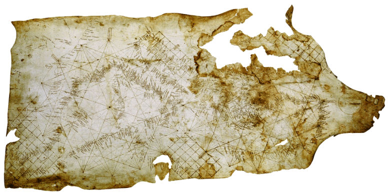
Ill. 11. Carta Pisana (c. 1290)
The coastline on naval maps is depicted accurately in order to use them in navigation. Makers of portolan charts use new methods of space representation based on mathematical calculations. Italian portolan charts show mostly the Mediterranean and related seas/ As to Catalonian ones, they included not only visited territories but also supposed ones. It is more than just a portolan chart and it often had a spherical form, usual for mappa mundi. So despite the coastline of naval charts is close to the real one, vast lands of continents could be influenced by the mythological data from traditional maps and contain the Riphaean mountains. There are several naval maps that show some mountains that are exactly or most probably the Riphaean ones. One of the variants of their representation on naval charts is a small mountain massive to the north of the Euxine Sea (ill. 12, 12a, 12b), as it is shown on 1325 and 1339 charts.
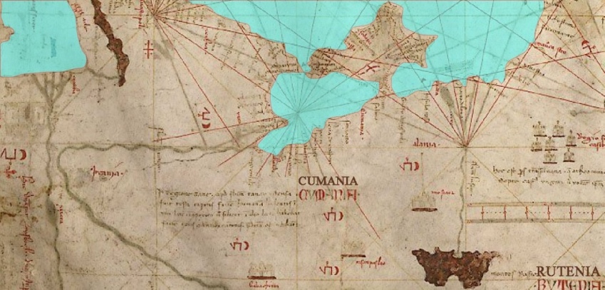
Ill. 12. Fragment of the portolan chart by Angelino Dalorto, 1325
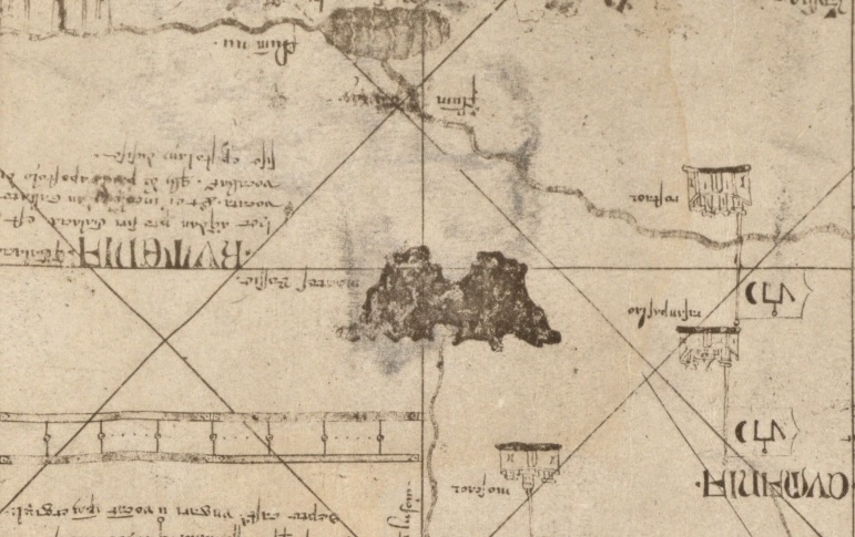
Ill. 12a. Fragment of the portolan chart by Angelino Dulcert, 1339
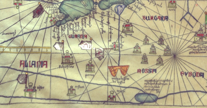
Ill. 12b. The Catalan Atlas by Abraham Cresques, 1375
There are mountains that are depicted very similarly in the Catalan Atlas by Abraham Cresques. This range is identified as mountains of Rossia. As on 1325 and 1339 portolan charts, they are located between Russia and Cumania. A river takes its origins in these mountains but it is not the Tanais as on many mappae mundi. The Tanais arises to the north from the lake, goes to the south-east approaching the Volga, and then flows to the west. These two rivers are close to each other in one place, it is similar to what Ptolemy has described. However, the Volga is straight that doesn't correspond to the depiction of the ancient geographer. Is it probable that Ptolemy had been able to influence mapmakers before his Geography was translated into Latin and he became well known in Western Europe?
Another variant of their depiction is a great mountain range stretching from the area to the north of the Black sea to the North-East (ill. 13, Munich, Bayerische Staatsbibliothek, BSB-Hss Cod.icon. 131).
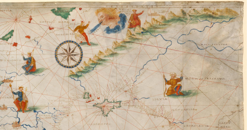
Ill. 13. The portolan chart, c. 1505, Italy
As it is seen, the Riphaean mountains are surrounded not by tribes of the Scythians as in traditional cartography but by Russian and Tatarian lands. By the way, on this map “rex Russie” and “rex Moshovichi” are different rulers despite Russia of that time was quite a united state with Moscow as its capital. Although the maker of this portolan chart tries to put realistic information about the lands to the north and east of the Black sea, he has not enough data to do it properly to the end. May be that is the reason for appearing on this map of the mountains that are most possibly Riphaean.
Six streams originate in this range and converge to three rivers. One of them is Tanais which traditionally begins, as we have seen, throughout the antiquity and the Middle Ages in the Riphaean mountains (that contradicts the point of view of Ptolemy) and flows into the Maeotidae Paludes, i. e. the Azov sea. The other river is the Rha fluvius, the Volga, that is known to be mentioned under that name by Ptolemy. Moreover, the influence of this ancient geographer reveals itself as follows: Tanais and Rha are very close to each other in one place as he has depicted. As we can observe, according to Ptolemey, Tanais originates in the Riphaean mountains, and the Volga in the Hyperborean. The mapmaker of this portolan chart combined these two ranges in one, that’s why the both rivers flowed now from one ridge. So the influence of Ptolemy is seen more than the one of monastery maps in this case. It is not surprising because the Geography written by this author was known in Western Europe from the beginning of 15th c. and earlier in the Eastern Roman Empire, many maps were made according to the instructions by Ptolemy during the final period of the Middle Ages21.
The maker of the portolan chart 1505 mixes the data taken from works of Ptolemey, traditional medieval cartography and quite realistic, but not very accurate, information about ethnic and political configuration in the region.
Such depiction of the Riphaean mountains had continuation in the next centuries cartography. For example, there is a gravure map by Abraham Ortelius made in 1590 according to ancient sources (ill. 14).
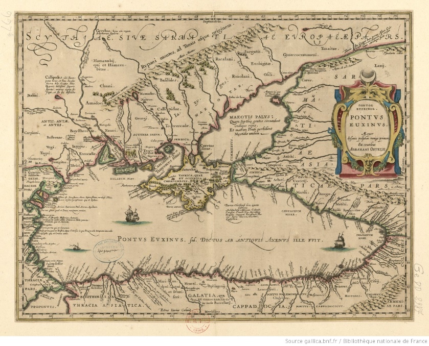
Ill. 14. Abraham Ortelius, Pontus Euxinus, 1590
Isidore of Seville as we know told that the Riphaean mountains were located “in capite Germaniae”. One can see them more likely “in capite Poloniae” on the map, mentioned above, new reality is considered. Orosius wrote that the Riphaean mountains make one part of the border between Europe and Asia. One can see such their location on many traditional medieval maps. May be on this portolan they perform the same funcion. Poland, Bohemia, Hungary and catholic Europe in the whole is located to the west of them. And the Tatars are observed to the east of the Tanais. Russian lands probably occupy the position on the border between two parts of the world.
The work of the Polish historian and geographer Matthew Mehovsky (1457–1523) “On Two Sarmatias” (published in 1517) has great historical and symbolic significance for the fate of the myth about the existence of the Riphaean Mountains. He researches in his treaties the contemporary history and geography of Eastern Europe and, in particular, of Rus.
Matthew was in fact the first in Western European historiography to give readers relevant information about this region, vigorously protesting against the fantastic data of ancient and medieval authors about Eastern Europe. He rejects their stories about the blessed Hyperboreans, the Arimaspi and the griffins, about two-headed, dog-headed and one-eyed people, about the horrors of winter, finally about the Riphaean and Hyperborean mountains. Here is what Matthew writes in the Introduction to his treatise22:
Many writers... claimed that in those northern regions are situated the most famous in the world mountains – Riphaean and Hyperborean, and from them no less glorious rivers flow, described and sung by cosmographers and poets: the Tanais, the Great and Small Borysthenes and the Volga – the greatest of the rivers. All this is far from the truth, and it will be not superfluous, basing on the experience (our universal teacher), to refute and reject this as an ignorant and unverified message... That there are no mountains there, called Hyperboreans, Riphaean and Alanean, we know this most precisely and see, that the aforesaid rivers arise and have their origins in the plain.
Thus, the ancient myth about the existence of the mysterious Riphaean Mountains in the north of Eurasia was dethroned. However, even after publishing of the treatise of Matthew Mehovsky the range of mountains, similar to the Riphaean ones, appears on the maps with meridians, e.g. in the atlases made by Battista Agnese in the 16^th^ c. (portolan charts there represent information mostly about coastline of seas) (ill. 15, 15a, 15b). However, the mountain range appears not on all maps by this mapmaker.
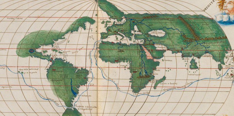
Ill. 15. Map from Atlas by Battista Agnese, c. 1541–1542
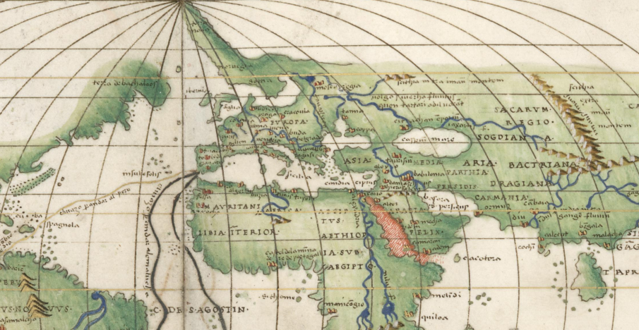
Ill. 15a. Map from Atlas by Battista Agnese, c. 1544
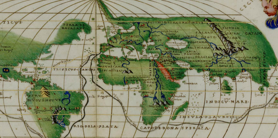
Ill. 15b. Map from Atlas by Battista Agnese
In any case the influence of Ptolemey is evident. Moreover, the legend has remained – the warm and fertile land of Sannikov has been looked for during last two hundred years in the Arctic Ocean; modern people write books, make films and organize scientific conferences about this land.
БИБЛИОГРАФИЯ / REFERENCES
Bagrov L. The History of Cartography. Moscow: Centrpoligraph, 2004. 319 p. (in Russian).
Багров Л. История картографии. М.: Центрполиграф, 2004. 319 p.
Ballabriga A. Le Soleil et le Tartare. L’image mythique du monde en Grèce archaïque. Paris: Editions de l'Ecole des Hautes Etudes en Sciences Sociales (Ed. de l'EHESS), 1986. 298 p.
Beckers W.J. Die rätselhafte Hochgebirge des Altertums, die sogenannten Rhipäen // Geographische Zeitschrift. 1914. Vol. 20. No. 9/10. P. 534-557.
Bolton J.D.P. Aristeas of Proconnesus. Oxford: Oxford Univ Press, 1962. 272 p.
Bridgman T. Hyperboreans: Myth and History in Celtic-Hellenic Contacts. New York; London: Routledge, 2005. XX+249 p.
Casson S. The Hyperboreans // The Classical Review. 1920. Vol. 34. P. 1-3.
Chekin L.S. Northern Eurasia in Medieval Cartography. Inventory, Text, Translation, and Commentary. Terrarum Orbis. Hisoire des représentations de l'espace: textes, images (History of the Representation of Space in Text and Image). Turnhout: Brepols Publ., 2006. 498 p.
Daebritz H. Hyperboreer // Paulys Realencyclopädie der classischen Altertumswissenschaft. 1916. Vol. 9. No. 1. P. 258-279.
Dion R. La notion d’Hyperboréens: ses vicissitudes au cours de l’antiquité // Bulletin de l’association G. Budé. 1976. No. 2. P. 143-157.
Dion R. Aspects politiques de la gographie antique. Paris: Les Belles Lettres, 1977. 305 p.
Fomenko I.K. The Image of the World on the Old Portolan Charts. The Black Sea Region. End of 13th – 17th cc. Moscow: Indrik, 2011. 424 p. (in Russian).
Фоменко И.К. Образ мира на старинных портоланах. Причерноморье. Конец XIII – XVII в. М.: Индрик, 2011. 424 c.
Geus K. Utopie und Geographie. Zum Weltbild der Griechen in frühhellenistischer Zeit // Orbis terrarum. 2001. No. 6. P. 55–90.
Harmatta J. Sur l'origin du mythe des Hyperborens // Acta antiqua Academiae Hungaricae, 1955/1956. Vol. 3. P. 57-66.
Harley J.B., Woodward D. The History of Cartography. Chicago; L.: The University of Chicago Press, 1987. Vol. 1. 622 p.
Herrmann A. Ottorocorrai // Paulys Realencyclopädie der classischen Altertumswissenschaft. 1942. Vol. 36. No. 3. P. 1888-1889.
Kiessling E. ῾Ρίπαια ὄρη // Paulys Realencyclopädie der classischen Altertumswissenschaft. 1914. Vol. 1 (2. Reihe). P. 846-916.
Klaudios Ptolemaios. Handbuch der Geographie: griechisch-deutsch / Stückelberger A., Graßhoff G. (eds). Basel: Schwabe Verlag. 2006. Vol. 1-2. 1018 p.
Kyriazopoulos A. The Land of the Hyperboreans in Greek Religous Thinking // Parnassos. 1993 Vol. 35. P. 395-398.
Lasserre F. Rhipaia ore // Kleine Pauly. Lexikon der Antike in fünf Bände. 1979. V. 4. P. 1417-1419.
Lazova T. The Hyperboreans. A Study on the Paleo-Balkan Tradition. Sofia: Centre of Underwater Archaeology. 1996. 87 p.
Macurdy G.H. The Hyperboreans // Classical Quarterly. 1916. Vol. 30. P. 180-183.
Mehovski M. Tractatus de duabus Sarmatiis. Moscow; Leningrad: AN SSSR, 1936. XI+288 p.
Меховский М. Трактат о двух Сарматиях. М.-Л.: АН СССР, 1936. XI+288 c.
Podossinov A.V. Eastern Europe in the Roman cartographic tradition. Moscow: Indrik, 2002. 504 p. (in Russian).
Подосинов А.В. Восточная Европа в римской картографической традиции. М.: Индрик, 2002. 504 с.
Podossinov A.V. Where sailed Odysseus to? To the geographical concepts of the archaic Greeks. Moscow: LRC Publishing House, 2015. 200 p. (in Russian).
Подосинов А.В. Куда плавал Одиссей? О географических представлениях архаической эпохи. М.: Языки славянских культур, 2015. 200 с.
Pyankov I.V. Riphaia, is it myth or reality // Ural’skiy sledopyt. 1978. No. 8. P. 44-48 (in Russian).
Пьянков И.В. Рифеи – миф или реальность // Уральский следопыт. 1978. № 8. С. 44-48.
Ramin J. Mythologie et géographie. Paris: Les Belles Lettres, 1979. 141 p.
Rausch S. Bilder des Nordens. Vorstellungen vom Norden in der griechischen Literatur von Homer bis zum Ende des Hellenismus. Eurasien-Abteilung des Deutsches Archäologisches Institut: Archäologie im Eurasien. Bd. 28. Berlin: Philipp v. Zabern GmbH. 2013. VIII+444.
Romm J. Herodotus and Mythic Geography: The Case of Hyperboreans // Transactions of the American Philological Assiciation. 1989. Vol. 119. P. 97-113.
Romm J. The Edges of the Earth in Ancient Thought: Geography, Exploration and Fiction. Princeton: Princeton University Press, 1992. 228 p.
Stenger J. Rhipaia ore // Der neue Pauly. 2001.Vol. 10. P. 992-993.
Thomson J.O. History of Ancient Geography. Cambridge: C.U.P., 1948. P. XI+427.
Thorndike L. The Sphere of Sacrobosco and its commentators. Chicago: The University of Chicago Press, 1949. 496 p.
Tomaschek W. Kritik der ältesten Nachrichten über den Skythischen Norden. I. Über das Arimaspische Gedicht des Aristeas // Sitzungsberichte der Kaiserlichen Akademie der Wissenschaften. Philos.-histor. Klasse. Wien. 1888. Vol. 116. S. 715–780.
Werhahn H.M. Hyperboreer // Reallexikon für Antike und Christentum. 1994. V. 16. P. 967-986.
van Windekens A.J. Les Hyperboréens // Rheinisches Museum. 1957. Vol. 100 (NF). P. 164-169.
Wikén. E. Die Ansichten der Hellenen über den Nordrand der Oikoumene vor Pytheas: Rhipaien und Hyperboreer // ΔΡΑΓΜΑ. Festschrift für Martin P. Nilsson. Lund, 1939. P. 540-552.
Yel’nitskiy L.A. Knowledge of the ancients about the northern lands. Moscow: The State Publishing House of Geographical Literature, 1961. 224 p. (in Russian).
Ельницкий Л.А. Знания дрeвних о северных странах. М.: Гос. изд-во географической литературы, 1961. 224 с.
-
Podosinov 2015. ↩
-
See about this “moving” Beckers 1914. P. 538: «Da im Laufe der Zeit die Vorstellung vom Bereich des Nordrandes der Erde eine vielfache Wandlung durchmachte, und die umgrenzende Peripherie sich der fortschreitenden Aufhellung nördlicher Erdräume von Fall zu Fall anpassen mußte, so wurden die Rhipäen in späteren Zeiten höher im N(orden) gesucht und angenommen als in früheren»; see also p. 548-549. Cf. Wikén 1939. P. 540-552; Stenger 2001. P. 992-993; Rausch 2013. P. 16-17. ↩
-
The first detailed exposition of the legend is preserved in Herodotus (IV, 32-35), although some references to it are found in earlier writers. The legend of Hyperboreans is described in various ways by many ancient authors. On the significance of the Hyperborean topos for ancient geographic literature and on their localization, see more: Daebritz 1916. P. 258-279; Harmatta 1955/1956. P. 57-66; Dion 1976. P. 143-157; 1977. P. 260-270; Ramin 1979. P. 55-71; Romm 1989. P. 97-113; 1992. P. 60-67; Kyriazopoulos 1993. P. 395-398; Werhahn 1994. P. 967-986; Lazova 1996; Bridgman 2005. P. 27-98; Rausch 2013. P. 49-55; 77-80. ↩
-
Aitia, fr. 186, 8: υἷες Ὑπερβ̣ορέων Ῥιπαίου πέμπουσιν ἀπ' οὔρεος. ↩
-
See, e.g., Servius ad Verg. Aen. XII, 366: Certum sit eum (sc. Boreas) de Hyperboreis montibus flare… - Certainly it (i.e. Boreas) blows from the Hyperborean mountains; Schol. Bern. ad Verg. Georg. III, 196: Hyperborei montes in Scythia, inter quos Aquilo inflat - Hyperborean mountains are in Scythia, Aquilon blows there; Schol. ad Stat. Theb. V, 390: Hyperborei enim montes trans Aquilonem sunt – Hyperborean mountains are situated behind Aquilon. The Rhipaean and Hyperborean mountains are identified or differenced by Eusthatius, Aeticas and Stephanos from Byzantium (Eustath., ad Dionys. Perieg. 314; Aethicus 717; Steph. Byz. 654; см. Beckers 1914. P. 538). ↩
-
See e..g. Bolton 1962. P. 1-2. ↩
-
Of course, we must not forget that there are only reconstructions based on the description of the map by Ptolemy. See new edition: Klaudios Ptolemaios 2006. ↩
-
See about this map: Podosinov 2002, 287–378. ↩
-
Topogr. Christ. 88C-89C; 185C-188D. Kiessling 1914, 865-867; cf. 869 about influence of ancient tradition on Kosmas: «Kosmas hat als Grundlage seiner astronomischen Erdkunde die authentische Schrift eines altionischen Meteorologen benutzt…». ↩
-
The same ideas were defended by Anonymous from Ravenna: Cosm. I, 9: Nam alii phi-losophi et prudentes viri dixerunt quod in arctoam partem infra Oceani mare innumerabili spatio atque investigabili itinere dei iussu maximi sunt montes, post quos, quando sol occasum accipit, totam perambulat noctem, usque dum rediens secundum suum tempus mane post ipsos montes iterum hominibus apparet… See in details: Podosinov 2002. 107–111. ↩
-
More about medieval maps see in: The History of Cartography 1987. P. 283–509. ↩
-
The simplest T-O schemes (for example, Vatican City, Biblioteca Apostolica Vaticana, Reg. Lat. 814, fov. 74v); diagrams contrasting the extreme North with the South (for example, Paris, Bibliothèque Nationale, Latin 4860, fov. 166v); climate maps (Berlin, Staatsbibliothek zu Berlin – Preußischer Kulturbesitz, Phillipps 1833, fol. 39v; Dijon, Bibliothèque municipale, 448, fol. 76; Paris, Bibliothèque Nationale, Latin 6415, fol. 69); maps with mixed structure of T-O and climate zones (for example, Munich, Bayerische Staatsbibliothek, CLM 4612, fol. 103v); Anglo-Saxon Mappa Mundi; Psalter World Map; Hereford Map and others. It seems that the Riphaean mountains are depicted without textual legend on Ebstorf map. These maps and all other monastery mappae mundi mentioned in this article are published in Chekin 2006. ↩
-
Oros. I.2.4–5: Europa incipit ut dixi sub plaga septentrionis, a flumine Tanai, qua Riphaei montes Sarmatico auersi oceano Tanaim fluuium fundunt, qui praeteriens aras ac terminos Alexandri Magni in Rhobascorum finibus sitos Maeotidas auget paludes, quarum inmensa exundatio iuxta Theodosiam urbem Euxinum Pontum late ingreditur. ↩
-
Oros. 1.2.52: Incipit a montibus Riphaeis ac flumine Tanai Maeotidisque paludibus quae sunt ad orientem... ↩
-
Isid. Etym. XIV, 8, 8: Riphaei montes in capite Germaniae sunt, a perpetuo ventorum flatu nominati; nam RIFE Graece impetus et ORME dicitur, APO TOU RIPTEIN. ↩
-
Leipzig Map (Universitätsbibliothek Leipzig, Rep. I 4 (Leihgabe Leipziger Stadtbibliothek), fol. 184 v); Vatican Map (Vatican City, Biblioteca Apostolica Vaticana, Reg. Lat. 571-V, fol. 71v); Map from the Alexandreis (Paris, Bibliothèque Nationale, Latin 8352, fol. 100v), Heidelberg Map (Heidelberg, Universitätsbibliothek, Salem IX, 39, fol. IV); Lambert of Saint-Omer Maps (Gent, Bibliotheek der Rijksuniversiteit, 92, fols 92v–93; Wolfenbüttel, Herzog August Bibliothek, Gud. Lat. I, fols 59v–60; Paris, Bibliothèque Nationale, Latin 8865, fol. 56; Leiden, Bibliotheek der Rijksuniversiteit, Voss. Lat. F 31, fol. 165v).
-
Fleury Type of Maps (Berlin, Staatsbibliothek zu Berlin – Preußischer Kulturbesitz, Phillipps 1833, fol. 39v; Dijon, Bibliothèque municipale, 448, fol. 76) and some illustrations to Beatus of Liebana's Commentary on the Apocalypse (New York, P. Morgan Library, M 644, fols 33v–34; La Seu d'Urgell, Museu Diocesà, 501, fols VIv–VII; Valladolid, Biblioteca de Santa Cruz, 433, fols 36v–37; available at URL: https://www.facsimilefinder.com/facsimiles/ beatus-of-liebana-valcavado-codex-facsimile#&gid=1&pid=8; Madrid, Biblioteca Nacional, Vitr. 14.2, fols 63v–64; London, British Library, Add. 11695, fols 39v–40). ↩
-
Chekin 2006. P. 93–120. ↩
-
Thorndike 1949. P. 112. ↩
-
The History of Cartography 1987. P. 371–463; Fomenko 2011. ↩
-
Bagrov 2004. P. 78–91. ↩
-
Sed et montes Alanos, Hiperboreos et Ripheos, in orbe terrarum nominatissimos, in illis regionibus septemtrionis affirmaverunt et ex eis non minus famosa erupisse flumina, per cosmographos et vates celebres scripta atque decantata, Tanaim, Boristenem Maiorem et Minorem, Volhamque, maximum fluminum, declararunt. Quod cum alienum sit a vero, non abs re, experientia docente, quae est magistra dicibilium, confutandum et reiciendum est, tan-quam prophanum inexperteque promulgatum. Scimus quidem et visu cognoscimus praefata flumina tria, magna siquidem, Boristenem, Tanaim et Volham, ex Moskouia oriri et defluere, Minorem vero Boristenem, quem Aristoteles Hipanis, alias Minorem Boristenem appellat, ex Russia superiori cepisse et in Maiorem Boristenem decurrere et ei commisceri. Montes autem Hiperboreos, Ripheos et Alanos nuncupatos illic non existere certo certius scimus et videmus et iam praedictos fluvios ex terra plana consurrexisse ac emersisse conspicimus. Mechovskij 1936. P. 128. Cf. ibidem. P. 163: Accipe quarto, quod montes Riphei et Hyperborei non sunt in rerum natura non in Scythia, non in Moskouia, nec usquam locorum, et cum fere omnes cosmographi asserant Tanaim, Edel seu Volham, Dzwina et magnos fluvios ex praedictis montibus effluere, conficta conficte et potius fabulosa inexperti scripsere. ↩
